Onward to Home Park Mill Lock 70 and a lot of the traffic noise disappears. The adjacent Home Park Mill was John Dickinson’s third paper factory, built in 1825, it closed in 1980. Before you reach Kings Langley Lock 69A you'll pass a residential development that has taken the place of the old Ovaltine factory. Chosen specifically for its canalside location, the world famous barley malt drink was produced here from 1913 to 2002.
The lock was renumbered 69A after the canal owners lost a long running dispute in 1816 with the local paper mill owners, who accused the canal owners of stealing their water. To resolve the problem the canal was re-routed to follow the River Gade with five locks instead of four and, instead of renumbering all the locks to the Thames, King's Langley became 67A.
An arm now leaves to the former Tooveys Mill which the canal company bought in 1846 after a dispute over water rights. It operated until 1978 and was then demolished to make way for housing.
You begin to approach Hemel Hempstead with football pitches, an angling lake and warehouses. After going under an impressive railway bridge, there's a busy road bridge, and you pass Waterways Experiences which provides 'accessible canal boating' for all. Here an arm leaves for Nash Mills and there's another arm just past Nash Mill Bottom Lock 69 where refreshment can be had at the Red Lion. The site was also accessible from what is now the Top Lock winding hole. Originally a corn mill, it was purchased in 1811 by John Dickenson. From 1887 it innovatively produced fine rag paper using electric power. Closure came in 2006.
By 1830 Dickenson and his partner operated five mills that were heavy canal users, receiving raw materials and coal before shipping out the finished product by an express service to Paddington and later King's Cross, although painted with the company livery they were operated by FMC. The company also had a fleet of their own boats and the association with canal carrying finally ended in 1970.
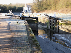
Next up is Apsley Mills that was purchased in 1809. The mill had been converted from corn to paper in 1778 and specialised in envelopes, tickets and cards etc from 1888. It closed in 1999. There's now a very smart marina opposite to where the mill was actually located and you don't have to look too carefully to discover where arms led into the mill from below and above Apsley Bottom Lock 67 and the Paper Mill pub.
The River Bulbourne leaves for Frogmore Mills just below Apsley Lock 66. Dating from 1774, and mechanised in 1803, this is the oldest paper mill of its type in the world and is now a visitor and education centre. Following Apsley Top Lock 65 with its boarded up cottage, you pass close to another former paper mill at Two Waters which was over a hundred years old when the Domesday Book was written. Making paper since 1763 until 1893, it unfortunately blew up in 1918.
This is a pleasant stretch albeit with background traffic noise until a bright orange DIY superstore emerges with the old Kodak HQ towering behind it. This is the site of Boxmoor Wharf, which from 1946 until closure in 1983, was home to Rose’s Lime Juice, and at one time was the world's largest lime juice depot, with as many as 25000 barrels in storage. Up until 1981 unprocessed lime juice was transported by narrowboat from the London docks to Boxmoor, the last regular narrowboat trade on the whole of the Gand Union. The juice was then filtered and sweetened before being delivered to a bottling plant in St Albans.
Passing the River Gade which leaves the canal after Bridge 151, you walk on through Boxmoor with its gothic revival church and river, cricket pitch where willow still strikes leather and meadows where cows continue to graze. Avoiding the centre of Hemel Hempstead, this was once a busy area with wharfs either side of the Fishery Inn which stands adjacent to Fishery Lock on Fishery Road near Fishery Moor next to Fishery Bridge and not far from Fishery Cottages.
From here there's a canalside cafe next to a trout fishery that was excavated in the 1970s and the canal follows a wide and well used tow path bordered by the familiar railway and River Bulbourne, a chalk stream that was once lined by watercress beds for the next two miles up to Northchurch. After the canal bends under the Winkwell Skew Railway Bridge, Winkwell moorings and dock are reached. Then, walking between the canal and the river, you reach Winkwell Bottom Lock 61 and a swingbridge to the idyllically located Three Horseshoes, there's a ten shilling fine if you're on a boat and don't close and fasten it.
After Winkwell Top Lock 59 aka Irishman's Lock (after a former lockkeeper), the A41 is barely audible and the country is pleasant if not notable. At the quaintly named Sewer Lock, the whiff in the air is from the adjacent Berkhamsted Sewage Works, the canal renews its acquaintance with road and rail but remains unremarkable past Bottom Side and Top Side locks.
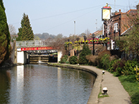
The approach into Berkhamsted starts here, crossing to the other side at bridge 143. Two pubs are in close proximity welcoming you to the ‘Port of Berkhamsted’ - the Rising Sun, which once stabled canal horses next to Berkhamsted Bottom Lock 55 and then the Boat at Ravens Lane Bridge.
Home of the Duke of Bridgewater, and Thomas Becket from 1156 -1165, and with a Saxon castle re-built in stone by William the Conquerer's half-brother Robert, not a lot of people know that sheep dip was invented in Berkhamsted, with the required sulphur and arsenic delivered to and leaving the factory by boat. After the canal arrived in 1798, coal, grain, building materials and manure were major cargoes carried by boats passing through and this activity created canalside industries including boat building and the manufacture of lock gates. You won't miss the red cedar totem pole opposite the Crystal Palace pub that was commissioned in 1968 from the native Kwakiutl people in Canada by timber merchants who once operated from the site.
Cross the Castle Street turnover bridge and you reach what was once described as a ‘vast plot or moore lying by the river’ opposite the railway station. There’s plenty of people enjoying the open space here and they are also much in evidence after the brightly decorated Lower King's Road Bridge and Berkhamsted Top Lock 53 near willow lined moorings. As you leave Berkhamsted under the modern wooden pedestrian Broadwater Bridge, you pass Gas 2 Lock (52) and Gas 1 Lock (51), these relate to the gas works situated between the canal, railway and Billet Lane which operated from 1906 -1959 and demolished in 1999. Suburbia continues until bridge 139 and Northchurch Lock 49 where there is a pumping station dating from 1945.
The railway and canal become your friends again but it’s now quiet countryside with not a lot to get excited about. Cross over at Dudswell Bottom Lock 48 with a re-developed mill nearby and there’s nothing much else to report until the award winning Cowroast Lock and sanitary station. The eponymous marina is close by and, if you're wondering, Cow Roast (spelt as one or two words) is a corruption of Cow Rest, a place where there were pens for cattle on their way to London.
We are now at the start of the 3 mile long Tring Summit and the canal passes through the one and half mile, 40ft deep Tring cutting completed in 1797, slicing through the countryside between the town and its station. The cutting has a surreal feel, dark with shafts of sunshine and tranquil with the periodic popping of a diesel engine, it appears deeper because the excavated earth was piled up along the sides.
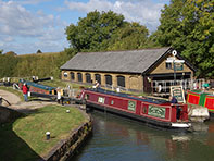
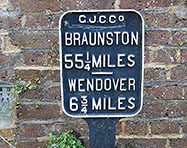
Tring itself is pleasant but not particularly noteworthy except for a bizarre zoological museum with animals collected by one of the Rothschilds, the banking family who built several properties in this area. At bridge 132 cross to the other side of the canal where there are visitor moorings. The cutting ends before you get to bridge 133, the Grand Junction Arms and the start of the Wendover Arm at Bulbourne Junction. This is a lively little place with a dry dock and a small iron works and it is where the Wendover Arm leaves the main line. The arm was initially envisaged to feed the Grand Junction with water from the Chilterns’ chalk streams but by 1897 it was clear that it was leaking more than it was supplying and actually taking water from the main canal. So the decision was taken to abandon it although a trust is now making great strides in restoring it further than Little Tring.
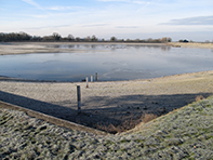
From here you reach the reservoirs at Marsworth, constructed purely to supply water to the canal. The towpath passes first the Marsworth, built in 1806 with an area of 24 acres and holding 55.5 million gallons, and then Startop’s End, constructed in 1817 over 26 acres and with a 106.5 million gallon capacity. The largest is the Wilstone reservoir which covers 119 acres and the smallest Tringford at 20 acres.