Northampton Arm
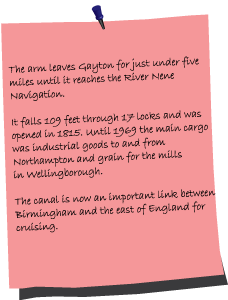
Departing the Grand Union at Gayton Junction, the Northampton Arm is 4¾ miles long with 17 locks. It opened in May 1815 to replace a horse railway and, ending at the River Nene, was built with the aim of providing a 'gateway to the sea'.
The walk begins on the narrow towpath next to a listed milepost, opposite the Toll House and Gayton Yard, a maintenance depot that is practically as old as the arm. If you are wondering where Bridge 1 is, it used to be over the mouth of the arm, so you walk to Bridge 2 in order to cross to the other side.
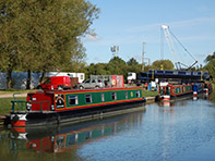
You quickly reach Gayton Marina which opened in 1980 on the site of a brick work's clay pit. British Waterways also used the clay for puddling. Following the marina there is a old loading wharf, it's next to Sandlanding Bridge 3, so it doesn't take a genius to work out that the main cargo loaded here was related to the sand extraction and brick making industry.
As the towpath follows the A43, traffic noise sets the tone for the rest of the walk, you are never too far away from busy main roads and the M1. That's not to say this isn't an enjoyable walk as the canal bends away from the attentions of the A43 to reach a winding hole and refurbished lock keeper's cottage at Lock 1, the only extant cottage of the three that were originally on the arm. Hawthorn and elderberry now line the tow path as you embark on the Rothersthorpe flight of locks.
Part of the IWA Northampton Branch's Art On The Arm initiative, at each lock there are mosaic plaques set into the grass. Each one depicts an aspect of canal heritage and has a letter with an associated image taken from nature, the letters eventually spell 'The Northampton Arm'.
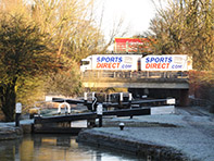
Lock 5 has an adjoining drawbridge, and, next to Lock 10, a group of wire sculptures stand amongst bits of canal infrastructure, a memorial bench and a bug hotel. The arm now goes under three substantial road bridges, these carry two feeder roads for the M1 and the motorway itself over Bridge 6B adjacent to Lock 12.
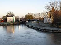
There is art to admire on both sides of the bridge, one has the seasons as its subject and, on the towpath side, you can learn about Northampton's history from the building of the Round Church in 1100 to recent floods. Just after Rothersthorpe Bottom Lock 13 the towpath improves significantly as you cross the Swan Valley aqueduct and stays well made for the rest of the walk.
before Wooton Lock 14 you'll notice Wooton Lock Narrows, the first of three narrows before Hardingstone Lock 15. Tall reeds become invasive but this is a pleasant walk as the canal runs parallel with the River Nene and Northampton comes into view. One obvious landmark is the National Lift Tower in the distance, this listed 418ft structure, also known as the Northampton Lighthouse, was opened by Queen Elizabeth II in 1982. One of only two in Europe it's used for R&D by lift companies.
The walk begins on the narrow towpath next to a listed milepost, opposite the Toll House and Gayton Yard, a maintenance depot that is practically as old as the arm. If you are wondering where Bridge 1 is, it used to be over the mouth of the arm, so you walk to Bridge 2 in order to cross to the other side.
You quickly reach Gayton Marina which opened in 1980 on the site of a brick work's clay pit. British Waterways also used the clay for puddling. Following the marina there is a old loading wharf, it's next to Sandlanding Bridge 3, so it doesn't take a genius to work out that the main cargo loaded here was related to the sand extraction and brick making industry.
As the towpath follows the A43, traffic noise sets the tone for the rest of the walk, you are never too far away from busy main roads and the M1. That's not to say this isn't an enjoyable walk as the canal bends away from the attentions of the A43 to reach a winding hole and refurbished lock keeper's cottage at Lock 1, the only extant cottage of the three that were originally on the arm. Hawthorn and elderberry now line the tow path as you embark on the Rothersthorpe flight of locks.
Part of the IWA Northampton Branch's Art On The Arm initiative, at each lock there are mosaic plaques set into the grass. Each one depicts an aspect of canal heritage and has a letter with an associated image taken from nature, the letters eventually spell 'The Northampton Arm'.
Lock 5 has an adjoining drawbridge, and, next to Lock 10, a group of wire sculptures stand amongst bits of canal infrastructure, a memorial bench and a bug hotel. The arm now goes under three substantial road bridges, these carry two feeder roads for the M1 and the motorway itself over Bridge 6B adjacent to Lock 12.
There is art to admire on both sides of the bridge, one has the seasons as its subject and, on the towpath side, you can learn about Northampton's history from the building of the Round Church in 1100 to recent floods. Just after Rothersthorpe Bottom Lock 13 the towpath improves significantly as you cross the Swan Valley aqueduct and stays well made for the rest of the walk.
before Wooton Lock 14 you'll notice Wooton Lock Narrows, the first of three narrows before Hardingstone Lock 15. Tall reeds become invasive but this is a pleasant walk as the canal runs parallel with the River Nene and Northampton comes into view. One obvious landmark is the National Lift Tower in the distance, this listed 418ft structure, also known as the Northampton Lighthouse, was opened by Queen Elizabeth II in 1982. One of only two in Europe it's used for R&D by lift companies.
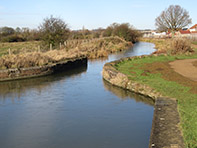
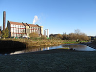
Briar Hill Meadows opposite makes this feel like a countryside walk up until Lock 16 where a high brick wall, built as a flood defence, heralds an urban landscape. After Bridge 17 the imposing Carlsberg Brewery comes into full view opposite apartment blocks that accompany Northampton Lock Narrows and the winding hole next to Northampton Lock.
This is where the Grand Union finishes, becomes the Nene Navigation and brings to an end a walk which has more than enough interest to make the constant rumble of traffic bearable.
View Northampton Arm in a larger map
Hover over photographs for extra information