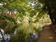
This attractive waterway, full of fauna and flora and completed in 1797, winds through open fields for 6.75 miles on the 390ft contour and under leafy canopies from Bulbourne through Little Tring, Drayton Beauchamp, Buckland Wharf and Halton to Wendover. 'The Navigable Feeder' was originally meant to feed water from local chalk streams and springs to the Tring Summit, while at the same time commercial traffic would take hay and straw to London and then bring back the resultant manure, coal was also important with various wharfs along the way.
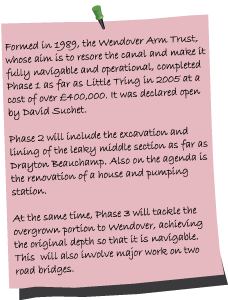
Quite the reverse happened as water continually leaked practically from the time it was built, particularly from the middle section, and it literally became a drain on the Grand Union. A lock was finally installed at Tringford and the canal closed in 1904, although water has continued to be piped from the section still in water past Drayton Beauchamp to Wilstone Reservoir. Now only navigable to Little Tring, the Wendover Canal Trust is refurbishing the rest of the arm in two phases with the aim of restoring the navigation all the way to Wendover.
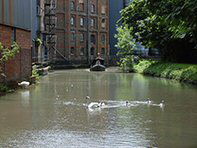
Starting on the pleasant and easy walk starting from Bulbourne Junction, the Toll House is the first of several places of interest along the way. From bridge 1 at Bulbourne, the towpath is quite narrow in parts and as you near bridge 2, passing a sewage outlet on the other side of the canal, you catch sight of the Heygates factory. This is Gamnel Wharf, the Tring base of Heygates since 1944, who mill over 100,000 tons of wheat annually and produce the wholewheat flour used in the nation's favourite tea time digestive. Shipments of grain via the canal to the mill continued until the end of World War II and from c.1812 to 1911 there was also a windmill providing power to the site. Next to the mill was Bushell's a tug, barge and boat builder, this business began in 1850 with John Bushell repairing the mill's boats and ceased when his grandsons retired in 1952.
As the noise from Heygates slowly decreases, you quickly enjoy very pleasant open countryside before reaching Tringford Pumping Station (1817) a grade II listed building that takes water from the four Tring reservoirs (built between 1802-1817) up to the arm and then onto Bulbourne Junction. Originally powered by a Birmingham made Boulton & Watt steam engine, electric pumps are now used to move approximately 2393 million litres of water each year. Initially this pumping station was one of three taking water from individual reservoirs but operations were centralized at Tringford and the other two, at Whitehouses (restored further along the arm) and Weston Turville (demolished) were closed.
Due to the work of the Wendover Arm Trust, the canal is now navigable and walkable for another 300 yards or so from Tringford Stop Lock. Originally this was a standard lock installed to prevent the arm taking water off the main line and was left open when there was sufficient water. Now only the top gates remain. Go under bridge 3 and you reach an 86ft winding hole. Although a concrete structure, the bridge was rebuilt in 2001 in the same style as the original which was demolished in 1973, faced with hand made bricks and fitted with replica rubbing strakes. However, to reconnect with the canal you must go up to the road from the bridge, go through Little Tring, then left on a public footpath to find the unrestored canal.
Damson trees line this very rural towpath and very quickly on the right you glimpse Wilstone Reservoir. Bridge 4 is on the site of a former swing bridge, Nearby are the remains of the restored Whitehouses Pumping Station (1802 - 1838) at a spot 'determined by Mr Telford' to take water from the reservoir. Converted into a double fronted cottage which is now demolished, the cellars, canal walls and water portals have been conserved. The cost of the on-going work carried out by the Trust is clearly visible and Bridge 4 and 4A are decorated with donor plaques including one for David Suchet who is a patron of the Trust.
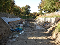
All along the canal there are masses of wild flowers, particularly at this point Traveller's Joy and Willowherb with Rosehips and Elderberries keeping them company. Preventing the canal from leaking on porous chalk proved difficult especially as the original puddling clay was not best quality. A replacement asphalt lining was laid in 1856-7 and initially this was thought to be successful (and cheaper), however whether through poor workmanship, materials or it being a 'rush job' to get boats moving again, the canal continued to leak. Seasonal springs are thought to have punctured the lining adding to damage caused by boats and earth movements. Restoration comprises profiling the banks, laying waterproof material held in place by concrete blocks and then covering with 300mm of spoil. At water level coir rolls provide a habitat for plants.
By the time you reach Drayton Beauchamp visitor moorings the canal is back in water but then becomes overgrown following the Saxon Way bridge (5A), which is named after the nearby burial site of a Saxon Princess discovered in 2001, and carries the Aston Clinton By-Pass. Just before the bridge a short diversion can be taken to St Mary the Virgin church, a smartly kept country Grade I listed church dating mainly from the 15th century but with a Norman font, 13th century brasses together with fine stained glass.
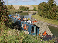
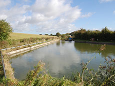
The bridge at Buckland Wharf is one that will need replacing if boats are to pass this way again. This section of the arm (Phase 3) has always held water but will need dredging, the banks will need strengthening and the tow path improved. The tow path crosses sides and there is a well situated bench to take your ease and admire the emerging Chiltern Hills with perhaps a glider overhead from RAF Halton. Bungalows are then passed with landing stages waiting for the restoration to be completed. The water is clear but shallow and full of reeds and nesting birds.
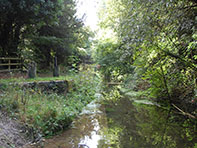
The canal straightens under Wellonhead Bridge into The Narrows adjacent to Cobblers Pits, where yews hide abandoned pits. Green Park is on the other side of the cut and the canal was lined in concrete to prevent water leaking into the now demolished Aston Clinton House which was purchased in 1853 by Anthony Nathan de Rothschild. A pattern now becomes established that when trees overhang the water it is clear, but when sunlight can penetrate, overgrowth takes over and the water virtually disappears from view.
Overall the towpath is very quiet but this is not to say you are in the middle of nowhere, MoD signs warn you to keep clear of the adjacent RAF training station before you go under the elaborate Rothschild Bridge which complements the chateau styled country retreat built for Alfred de Rothschild in 1883, Edward VII is said to have networked there with Lillie Langtry but it has been the RAF Officers' Mess since 1918.
At Halton you cross to the other side of the road, there are tennis courts and open fields with the canal guarded by sentry trees that stud the banks. You now pass through woods that hide Weston Turville Reservoir, built in 1799 as a repository for excess water in order to placate local mill owners, it is now a wildlife sanctuary. Before Perch Bridge, the canal threatens to disappear completely but suddenly opens up at The Wides, a former mill pond fed by springs in an area that was marshy grassland pre-canal.
Bridge 11 is an unusual narrow wooden footbridge located on the site of a former railway bridge taking a line constructed by Great War German PoWs from Wendover Station to Halton Camp. Progressing under shady trees the canal continues to Wendover Basin and finishes at Wharf Road. Here water enters the canal from Heron Brook. A water flow gauge, thought to be oldest in the UK, has operated here since 1841.
For further information visit: www.wendovercanal.org.uk and www.tringlocalhistorymuseum.org.uk
View Wendover Arm in a larger map
location information